Townsville Solar City
| Add to Favorites | Help | Printing | Legal |

SOE banner

| Database | City View | Eco Map | Site Map | Search |

Click to enlarge - Charters Towers Road from Castle Hill
The Land

Theme Summary
Pressure
Condition
Response

Click image to enlarge - North Ward and the Strand Beach

Introduction

The way we manage land quality issues affects the whole environment. Without adequate vegetation cover and land management, nutrients, chemicals and soil particles are washed from the land into rivers, creeks, estuaries and the marine environment (ANZECC Core Indicators 2000). This runoff from the landscape can have negative impacts on our health and aquatic life. Maintaining vegetation cover to stabilise soil and landforms is critical for protecting biological diversity, sustainable primary production and a stabilised landscape. Consequently, many issues discussed here are closely related to matters covered in the sections on Biodiversity and Inland Waters.

There are five core indicators for SOE reporting as it applies to land – these are listed below.

  • Land use and management
  • Erosion
  • Salinisation
  • Acidification, and
  • Contamination

All of these pressures are closely associated with population expansion, industrial and agricultural development. Given the projections for growth in all three of these in Townsville, the preserving the environmental values of the land is an important challenge for the city and the region.

Go To Top


Wallaby
Click image to enlarge - Wallaby

Pressure

The pressures on land may be understood by examining the extent, severity and cause of soil erosion and degradation, salinity, acidification and issues surrounding the disturbance of acid sulphate soils (ASS). These pressures also include contaminated land, where specific contamination has occurred on individual sites. Different and changing land-uses are a major reason for changes in environmental condition. Land management practices associated with different uses have varying effects on the ecological functions, attributes, and processes. There is currently no national land use map (Core Indicators 2000). As land is developed for different uses or use changes from one to another, potential environmental impacts may not always be adequately taken into account. Past land management practices have included filling of mangrove “wastelands” for development and landfills and filling of tidal areas for aquaculture purposes. Many such developments, some of which fail for economic reasons, were with the benefit of hindsight clearly undesirable in land quality and broader environmental terms.

Currently well understood constraints to land use – in terms of protecting environmental values include: preserving of water supply catchments and aquifers, minimising disturbance of acid sulphate soils in low lying lands (5 metres AHD), site wetness – wetland indicator, soil reactivity and responsiveness, good quality agricultural land (good soils), steeply sloping land (high erosion potential), susceptibility to storm surge and flood.

Soil erosion though a natural process, can be by poor land management.  Poorly managed land can cause pollution impacts (transport of sediment/silt) and also future land failure (loss of sediment/silt) . Inappropriate human activities such as mismanaged recreational use of steep slopes or low lying areas and vegetation clearing can lead to similar results. Exposure and clearing of vegetation on even low lying poorly structured soils (dispersive clays) and on steep slopes can degrade both the landform itself and impact on downstream aquatic environments via sedimentation.

There are also substantial economic costs for clearing drains of sediment, managing weeds and installing pollution trap infrastructure. There is also loss of public amenity when soil and sediments are deposited in drains, creeks and waterways – something which can lead to unwanted grass and weed growth.

Go To Top


Castle Hill and Magnetic Island from the top of Mt. Stuart

Click image to enlarge - Castle Hill and Magnetic Island from the top of Mt. Stuart

Condition

Catchment Runoff & Catchment Condition
Townsville Catchment Areas
Land Use Constraints
Land Condition
Environmentally Relevant Activities
Soil Erosion
Contaminated Sites

Townsville’s environment is characterised by harsh seasonal contrasts peculiar to monsoonal and seasonally dry climates. Our local landscape and vegetation reflect these climatic extremes. Our local environments typically include low lying fresh and marine/estuarine wetlands, rivers, creeks and tropical savanna hills. These hills provide the scenic backdrop to Townsville’s urban environment and protect catchments (soil, water and vegetation) where they remain undeveloped (Mt. Stuart, Muntalunga, Sisters, Many Peaks Ranges, Mt. Louisa and Castle Hill). These same hills are also in a relatively pristine condition with few weeds probably due to seasonal dryness and lack of human related impacts (i.e. forestry, grazing, mining, housing). Freshwater and estuarine creeks and wetlands protect our coastline and to an extent buffer the marine environment from human impacts (sediment and pollutants). Hills have also proven in recent years to be vulnerable to serious erosion events. As a consequence of land slips on Castle Hill (2000) and Magnetic Island (1998) the city has learned very clearly that Townsville is much more unstable in terms of soil and geology than previously thought.

Managing water catchments is vital to maintaining land quality by preventing erosion, retaining trees and grass cover, and ensuring high water quality in rivers and creeks. This aspect of land quality is discussed under Inland Waters and Townsville Stormwater Management section of this report.


Townsville Catchment Areas

Water Course

Catchment Area (km2)

Major Creek (tributary of Haughton River)

462 Gauging Station (GS)

Ross River (part of)

750 GS Dam

Bohle River (lower part of)

213 GS Mt. Bohle

Stuart Creek (includes Rocky Springs area)

57

Alligator Creek

72

Killymoon Creek

21

Source: Compiled from Townsville-Thuringowa Strategy Plan Natural Resources Management Policy Paper (1996)


Catchment Runoff & Catchment Condition

Climatic and topographical factors and soil and vegetation conditions interact in complex processes to produce varying runoff water quality within the Townsville region  (TTSP NRM NRWG 1996). There are four gauging stations, which monitor river levels and flows in the Townsville LGA. Flow records are available for Ross, Bohle, Majors, and Alligator Creek. Based on records of stream-flow data, TTSP has estimated long term average runoff (see table below).

Basin #

Basin Name

Basin Area
(km2)

Mean Annual Runoff
(x 1000 Ml)

Mean Annual Rainfall
(mm)

RO/RF
%

% of Basin
Gauger

1180

BOHLE

303

38

1028

22

54

1181

ROSS

858

108

1028

14

87

1181

ALLIGATOR

143

32

1028

45

48

1190

MAJOR

568

105

1197

19

82

Catchment Condition has been investigated broadly by previous government agencies (The Condition of River Catchments in Queensland DPI 1993) and broadly discussed locally by community Landcare (Section 1 - "Whole of Catchment Approach"in their document "Community Plan for Natural Resources Management in Townsville-Thuringowa.).

Download Section One (.pdf)
A Whole of Catchment Approach

Produced by Townsville Thuringowa Landcare Association


Land Use Constraints

TCC has undertaken land use constraints mapping that has identified a number of key themes. These include: water supply catchments and aquifers, acid sulphate soil potential and exposure in low lying lands (<5 metres AHD), site wetness (an important wetland indicator), soil reactivity and responsiveness, good quality agricultural land, steeply sloping land (high erosion potential), storm surge and flood liable lands.

Following a series of wet periods, severe and naturally occurring land slips and debris flows can occur and in the past have impacted on built up areas (housing and tourist accommodation). This phenomenon has drawn attention to the issue of landscape stability of surrounding dry tropical hills and slopes.

Colour composite Satelite image
Click ESYS image to enlarge - Land use


Land Condition

Land condition is an associated indicator which, is covered in this section. In the condition assessment of Queensland Catchments produced by the Department of Primary Industries it was stated that there has been little change in vegetation cover since settlement other than due to urbanisation – 4% loss of low open woodland (The Condition of River Catchments of Queensland – DPI 1993). Reports by the Department of Natural Resources - Land Cover Change (1990-1995 & 1995-2000 DNR) confirms this. A recent land cover assessment of Townsville LGA made a 'snap shot' comparison between two years (1996 & 2001) and confirms that little change has occurred recently, except for small areas of urban development (see map).

Landscape condition also describes the degree and impact of pest plants and animals. Such infestations have been broadly mapped for the Townsville area (TCC Draft Pest Management Plan and TCC Revegetation Strategy .pdf 242kb). Evidence suggests that feral pigs also play a significant role in the spread and propagation of native weeds (EPA, 1999). The impact of feral animals and plants on the land requires further review and analysis.

Wildfire and vegetation management also have an impact on land (catchment) condition. However this element of land management is addressed under Biodiversity.

Mount Elliot
Click image to enlarge - Mount Elliot


Environmentally Relevant Activities

Council’s Environmental Health Services has land use permitting  responsibilities under the Queensland Environmental Protection Act 1994. TCC has issued 406 Licences (for various Environmentally Relevant Activities (ERA’s). Such activities include motor vehicle workshops, concrete batching plants, abrasive blasting, and metal surface workshops.

In addition Council has issued 165 Environmental Approvals for activities such as petrochemical product storage, wood product manufacturers, boiler making, engineering businesses and dog kennels.  A licensed ERA imposes regulation on waste and pollution management during operations of the activity. The type of environmental protection required is not always specified in operational licences, but is determined by the business in accordance with the relevant Trade Waste Policy and environmental legislation. In summary, an operation cannot discharge to stormwater but only to sewer, unless it can demonstrate that any discharge conforms with acceptable water quality limits. Some business activities may require bunding for storage of chemicals and fuels, and oil/water separators to treat wastewater prior to entering sewer.

All licensees are required to submit an annual return and are subject to environmental audits and inspections. At any one time there may be unlicensed activities operating in the community. These activities are eventually reported to Council or the EPA and may be subject to legal action under the Environmental Protection Act.


Soil Erosion

Townsville’s unique climate and soils pose specific challenges for soil erosion and sediment control. These features are not overlooked by Local or State Authorities.

Townsville’s climate features intense rain events (generally associated with monsoonal or cyclonic rains) which demand management of deep and fast water flows over steep slopes and flooding on the plains. Conversely, the combination of extended dry periods, poor soil cover, disturbances and strong winds produce wind erosion and dust nuisances that must be managed.

Also of particular importance are the varied landscapes and soils of the Townsville area. Soil erosion control structures must be designed to take into account steep slopes, shallow rocky soils, clay-rich ancient marine sediments and soils formed on stream sediments with a strong tendency to disperse, swell/shrink, crack, or erode.

Soil erosion and sediment control is therefore an important issue in Townsville and receives a particular focus from State and Local Government.

The Queensland Environmental Protection Act (1994), for example, states that a person must not undertake activities that cause or threaten to cause harm to the environment. Any activities that do so are liable to penalties under the Act.

The Townsville City Council works within the framework of the Environmental Protection Act 1994 which, among other things, requires developers to prepare soil erosion and sediment control plans for development sites (e.g. Fairfield; Annandale; Riverside Gardens).

In recent years self regulating controls have been implemented by the development industry on new housing subdivisions. These include sediment traps, detention ponds, jute matting, sediment fences and drainage-ways. However, these controls are not always properly designed, installed, maintained or monitored. Where this is the case, offenders may be fined or, in the worst cases, prosecuted.

To raise awareness of soil erosion and sediment control policies and management strategies, Council has sponsored a soil erosion and sediment control (SESCP) training course plus made available other information.

The SESCP training course is designed for the building/urban development industry and the urban/rural land management sectors. The course is focused on the needs of both practitioners and regulators.

Training in appropriate methods of soil erosion and sediment control is of increasing importance. Both individuals and companies are now liable to significant fines under Sections 31 and 32 of the Queensland Government’s Environmental Protection Policy (Water). It is now illegal to place sediment or pollutants in a position that they can enter waterways. The EPA has power to issue on-the-spot fines under these sections of the EPA Water Policy. Penalties that range from between 50 and 4165 penalty units ($3750 to $312,375 in 2001) or imprisonment for 5 years can be levied under the Act.

SESCP Courses have been held annually in September. For enquiries about the SESCP course, contact Integrated Sustainability Services at TCC on 4727 9520.


Contaminated Sites:

Currently, contaminated sites are registered with the EPA Contaminated Land Unit in Brisbane. Although Council is notified of inclusion of these sites on the Environmental Management or Contaminated Land registers, there is currently no available mapping or detailed analysis of the potential for environmental harm. Council does, however, maintain records on Contaminated Land. Existing landfills are run in accordance with approved Council’s own Environmental Management Plans and State Government  obligations under the  Environment Protection Act. The EPA on Contaminated land in Queensland and Townsville.

Go To Top


Burdekin Plum fruit and leaf

Click image to enlarge - Burdekin Plum fruit and leaf

Response

Land
Soil Erosion and Sediment Control
(Policy, Guidelines and Courses)

Environmentally Relevant Activities
Environmental Health
Healthy Cities Plan
Contaminated Land


Land

In relation to the pressures that impact on the environmental quality of the land in the Townsville region the City Council has developed a number of responses.

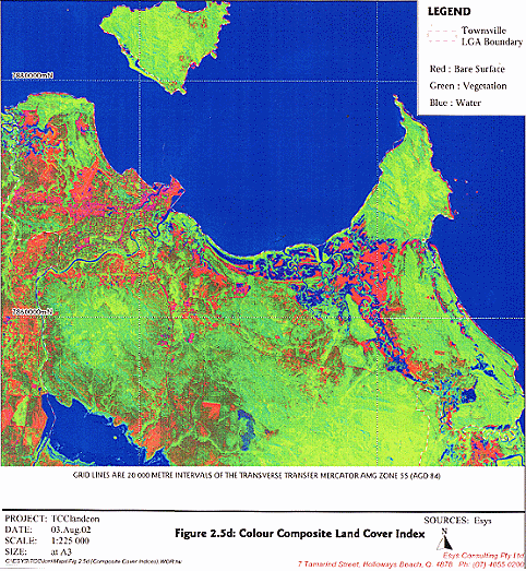
TCC has recently completed an Assessment of Loss of Undisturbed Vegetation by Satellite Imagery. This assessment by Esys Consulting Pty Ltd, provides a snap shot comparison of Land condition and vegetation loss between 1996 and 2001. This work complements the work by DNR (Land Cover Change) and provides a more detailed analysis for these two time periods (1996 & 2001). In combination, the studies show that there has been little loss of vegetation in recent years in Townsville.

A Land Use Constraints Analysis was established for Townsville Thuringowa (TTSP Land Use Constraints Analysis 1997) and led to a final results map. This was subsequently used in finalising the Regional Strategy Plan and can also be used  by Council for land use decisions.  This mapping include acid sulphate soils and erosion risk mapping (refer TCC GIS and Soil Erosion Guidelines).

Council is currently undertaking a new town planning process under the Integrated Planning Act (1997) or City Plan. This new plan is due for completion by end of 2003 and will help to guide and direct efforts to manage all environmental aspects of development and urban growth.

Council has prepared guidelines to help developers to comply with the city’s environmental management strategies (Soil Erosion Sediment Control; Open Space and Landscape Transitional Policies). Other guidelines under preparation cover appropriate landscape design; architectural aesthetics; the long-term maintenance requirement of the development; the energy efficiency of the development; and the environmental impact of the project.

The TCC is now requiring development to set aside riverbank and wetland environments in projects  on the mainland (Riverside Gardens and Fairfield) and on Magnetic Island (Horseshoe Bay and Nelly Bay).

We are requiring Environmental Management Planning for large scale developments and industry;

Regulating operational aspects of business and industry for environmental considerations via devolved powers under the Queensland Environmental Protection Act 1994 (Environmentally Relevant Activity assessment and requirements).

Council can report environmental offences (soil erosion, sediment, and rubbish) under Sections 31 and 32 of the Environmental Protection Policy (Water) to the EPA for action.

Developing a native plant guide and CD-ROM for landscape architects and builders/developers

TCC has also completed a Land Stability Study and adopted a Transitional Planning Policy for Land Stability to ensure land is developed and built on appropriately. Maps of steeply sloping land are also available to assist Council in land use decision making


Soil Erosion and Sediment Control
(Policy, Guidelines and Courses)

Townsville City Council recognises that it can assist many in the community to control and prevent soil erosion through well targeted programs and leadership on the issue. We are working with the community in various ways to demonstrate leadership and foster tangible improvements in this area. For example, the Soil Erosion and Sediment Control Policy is reducing erosion risk through targeted training and techniques, and the use of Acid Sulphate Soils (ASS) training kits.

A Soil Erosion Risk Map is provided as part of the TCC Soil Erosion Guidelines.

In light of the dangerous landslides of recent years in the city and on Magnetic Island, TCC has brought in rules that require developers to better address land stability constraints. TCC recognised that it can assist many in the community to control and prevent soil erosion through well targeted programs and leadership on the issue. The TCC is working with the community in various ways to demonstrate leadership and foster tangible improvements in this area.

To assist planners, regulators and engineers with ability to effectively manage and regulate development/building sites, Council in collaboration with leading professionals in the soil and water management industry has coordinated the formation of a five day Soil Erosion and Planning Course for North Queensland. This has meant accredited professionals are beginning to emerge across the whole of Northern Australia throughout the development and building industry. To date, 87 people from local government, engineering, environmental and building industry have completed the course from across Northern Australia (Mackay to Northern Territory). Of these 18 have become qualified as accredited Soil Erosion and Sediment Control practitioners in Northern Australia. Click for information about the SESCP Course.

Soil erosion awareness training for builders and subcontractors has also been coordinated by TCC and delivered to 80 people from the building industry.

Council has also recently adopted a Transitional Planning Policy on Soil Erosion and Sediment Control. This policy provides the guidelines and directions for managing soil, water and sediment on development sites. The Policy is accompanied by a set of flyers about on-site Soil and Sediment Control. Council produced these documents based on information obtained from Brisbane City Council and the Engineering Institute of Queensland.


Environmentally Relevant Activities.

As stated previously, annual monitoring and environmental audits are conducted by Council’s Environmental Health Services (EHS) on licensed and approved activities.


Environmental Health

In order to inform the public about the role that TCC Environmental Health Services plays in the Community, the Department has developed a series of interpretative posters under the title "…is a part of environmental Health". See below:

Environmental Health Posters

Environmental Protection
Environmental Protection 2

Waste Management
Waste Management 2

Environmental Health Services
Environmental Health

Mosquito Management
Mosquito Management 2

Environmental Nuisances
Environmental Nuisances 2

Animal Management
Animal Management 2

Disaster Management
Disaster Management 2

Flammables and Combustibles
Flammables and Combustibles 2

Safe Food Practices
Safe Food Practices 2

Skin Penetration Practices


Hairdressing Practices

Click for TCC Environmental Health website.


Healthy Cities Plan

In addition TCC Environmental Health Services with the support of other Council departments, is producing a "Healthy Cities Plan". This plan takes into account all aspects of a Healthy City, including life style, recreation, natural environment, water quality, air pollution, as well as traditional environmental health concerns (e.g.. safe practices, waste management, preventative health, and mosquitos).


Contaminated Land

Council has a number of programs in place in relation to the identification, remediation and monitoring of contaminated sites. The  Council is responding to the problem of contaminated land in three main ways.

In the first instance, the Council is working to improve knowledge and risk management in relation to the large number of contaminated sites in the Townsville local government area. Currently, the Council is assembling a range of data sources on contaminated sites – some held at State Government level, others locally – in order to produce a more definitive assessment of existing and potential contaminated land.  

This initiative has been commenced in part due to the inadequacy of existing information available. Presently, proven contaminated land which is causing or may cause serious environmental harm is listed with the Queensland EPA on the Contaminated Land Register (CLR). Sites recorded on the Environmental Management Register (EMR), on the other hand, pose a low risk to human health and the environment under the current land use. Research by the Townsville City Council has identified some sites which are listed on neither.

The program of information gathering by the Council would incorporate CLR, EMR and other sites into a Geographic Information System (GIS) that would, in addition to location, cover ownership, level of contamination, and existing or previous environmental management programs applied. This will significantly improve the capacity of the Council to plan and manage the risks potentially posed to the local environment.

Click here for EPA overview of Contaminated Land in Townsville

The second area where the City Council is responding is in requiring detailed site assessments to be undertaken when applications or proposals for use or change of use of registered contaminated land are made then detailed site assessments are undertaken (e.g. Reid Park; Soundshell).

The third area of council response relates to on-ground remediation works to reduce the risks posed by contaminated sites.  TCC has in place a number innovative urban stormwater management programs designed to improve the quality of freshwater resources on land and flowing into Cleveland Bay. Funded by the National Heritage Trust and the Urban Storm Water Initiative, EMS has coordinated these projects with consultants, Citiworks, and local community groups. A number of these programs are outlined below.

Bicentennial Park is an old landfill along the Ross River and follow overland stormwater flow problems has had erosion of the bank leading to exposing of landfill rubbish. In 2000 this site was remedied with best practice riverbank protection and overland stormwater management. This work was based on Soil and Water Management Planning previously carried out by Council for the ex-landfill site.

Reid Park is one of Townsville’s contaminated sites, the scene of a disused landfill. TCC has established a stormwater management system here which is built into the abandoned landfill site. The trilock lined gross pollutant trap feeds water into a constructed tidal saltwater wetland for nutrient scrubbing and sediment removal. Both the gross pollutant trap and the wetland are tidally flushed.

Another contaminated site in Townsville which the City Council is addressing is the North Railway Yards. A subsurface stormwater drain feeding from Walker Street to the Ross Creek has been installed. Using riblock lining technology, the 100m long stormwater pipe has been plastic lined. This has extended the longevity of the concrete pipe and has prevented the intrusion into the pipe of contaminated water from the railway yards soil.

Stormwater management systems associated with light industrial areas are an important means of minimising land contamination by preventing stormwater pollution from reaching the waterways. These projects also have the benefit of inculcating an appreciation of urban waterways and therefore lending pressure against the lands becoming contaminated in the first place. Some of these type of projects in place in Townsville include:

Lakes Stage 2: This project is a linear stormwater treatment system incorporating a litter trap, rock lined channel, gross pollutant trap with tri-lock and a freshwater wetland and another rock lined channel. It polishes stormwater from a light industrial area that feeds into the Lakes. Sunfish, Townsville Port Authority and Conservation Volunteers Australia are involved in the environmental monitoring of the site.

Greg Jabs Court: This is a former Council trapezoidal drain that had become choked with typha and paragrass. This drain serviced a light industrial area and become an ineffective hydraulic corridor. This project saw the grasses removed from the drain, riparian vegetation planted along the banks, and a stormwater management system constructed. This system consists of a gross pollutant trap, two rock ripples and three constructed ponds.

Cumuglia Street: Two lots were taken from a light industrial zone and an elaborate stormwater management systems was developed. The system incorporates three gross pollutant and sediment traps and a series of wetlands. During low flows, water moves slowly through these wetlands, and in high flows, stormwater flows straight over the top.

These projects have been developed by TCC EMS in conjunction with Citiworks, Citiwaste, and local community groups and businesses in Townsville, with funding from the Commonwealth Government via the National Heritage Trust and the Urban Stormwater Initiative. Further information about these projects and information sheets can be found via the hyperlinks in the Inland Waters Section of the SOE.

Go To Top


Eucalyptus new leaf - a response to the Dry Season