![]()
|
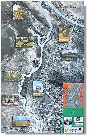
Mundy Creek Natureway |
|
|
Following invasion by para-grass and Tilapia fish, the environment is being rehabilitated through weed control and revegetation with indigenous plants. Mundy Creek Natureway provides a natural scenic route connecting Garbutt and Rowes Bay and offers panoramic views encompassing Many Peaks Range, Castle Hills, Mt. Louisa, Mt. Stuart, and Magnetic Island. Vegetation you'll see includes open space grasslands, sedgeland, mangroves and eucalyptus woodlands. Over 120 bird species (see bird list) have been recorded along the Natureway, from majestic brolgas and eagles to tiny finches and bowerbirds.
|
|
The main aerial photograph, taken in 1941 highlights in light blue the original path of Mundy Creek, as it was then. The dark curved line in foreground shows the Mundy Creek's new "channelised" course with its "new" environmental values of mangrove and sedgeland. Mundy Creek
was originally a string of freshwater swamps full of waterlillies, brolgas,
and barramundi. The environment is now being rehabilitated through weed
control, revegetation with indigenous plants (see Town
Common Aboriginal Food Trail brochure) and community awareness (Mundy
Creekwatch with Conservation Volunteers Australia and TCC), Today Mundy Creek Natureway provides a natural scenic route connecting Garbutt and Rowes Bay. The area has been modified over the years by drainage and reclamation works and now has established new environmental values through its saltwater grassland and mangrove wetlands. |
|