| Layer Metadata |  |
|
Metadata for Marine Benthic Substrate - CAMRIS
| Data Set | ||
| DSIN | 10445 | |
| Title | Marine Benthic Substrate - CAMRIS | |
| Custodian | Environment Australia - Environmental Resources Information Network | |
| Jurisdiction | Australia | |
| Description | ||
| Abstract | This database contains information about the distribution of
10 different types of sea floor sediment in the Australian region. It was
derived from data collected and mapped by the Ocean Sciences Institute,
University of Sydney.
CAMRIS, standing for the Coastal and Marine Resources Information System, is a small-scale spatial analysis system developed in collaboration by several divisions of Australia's Commonwealth Scientific and Industrial Research Organisation (CSIRO), as part of the CSIRO Coastal Zone Program. | |
| Search Word(s) | Benthic | |
| Geographic Extent Name(s) | Queensland | |
| Coordinates | N: | |
| S: | ||
| E: | ||
| W: | ||
| Data Currency | ||
| Beginning date | 1/01/1995 | |
| Ending date | 30/06/1996 | |
| Dataset Status | ||
| Progress | Complete | |
| Maintenance and update frequency | Not planned | |
| Access | ||
| Stored Data Format | DIGITAL - ArcView Shapefile (.shp) | |
| Available Format Type | DIGITAL - ArcView Shapefile (.shp) | |
| Access Constraint | For use in CHRIS/ACAWeb only | |
| Data Quality | ||
| Lineage | ERIN: Data were projected to geographics using the WGS84 datum and spheroid, to be compatible for the Australian Coastal Atlas. Ocean Sciences Institute extracted the data from the AUSEABED database, and sent to CSIRO. As with all CAMRIS data were stored in VAX files, MS-DOS R-base files and as a microcomputer dataset accessible under the LUPIS (Land Use Planning Information System) land allocation package. CAMRIS was established using SPANS Geographic Information System (GIS) software running under a UNIX operating system on an IBM RS 6000 platform. A summary follows of processing completed by the CSIRO: 1. r-BASE: Information imported into r-BASE from a number of different sources (ie Digitised, scanned, CD-ROM, NOAA World Ocean Atlas, Atlas of Australian Soils, NOAA GEODAS archive and Complete book of Australian Weather). 2. From the information held in r-BASE a BASE Table was generated incorporating specific fields. 3. SPANS environment: Works on creating a UNIVERSE with a geographic projection - Equidistant Conic (Simple Conic) and Lambert Conformal Conic, Spheroid: International Astronomical Union 1965 (Australia/Sth America); the Lower left corner and the longitude and latitude of the centre point. 4. BASE Table imported into SPANS and a BASE Map generated. 5. Categorise Maps - created from the BASE map and table by selecting out specified fields, a desired window size (ie continental or continent and oceans) and resolution level (ie the quad tree level). 6. Rasterise maps specifying key parameters such as: number of bits, resolution (quad tree level 8 lowest - 16 highest) and the window size (usually 00 or cn). 7. Gifs produced using categorised maps with a title, legend, scale and long/lat grid. 8. Supplied to ERIN with .bil; .hdr; .gif; Arc export files .e00; and text files .asc and .txt formats. 9. The reference coastline for CAMRIS was the mean high water mark (AUSLIG 1;100 000 topographic map series). | |
| Positional Accuracy | +/- one degree | |
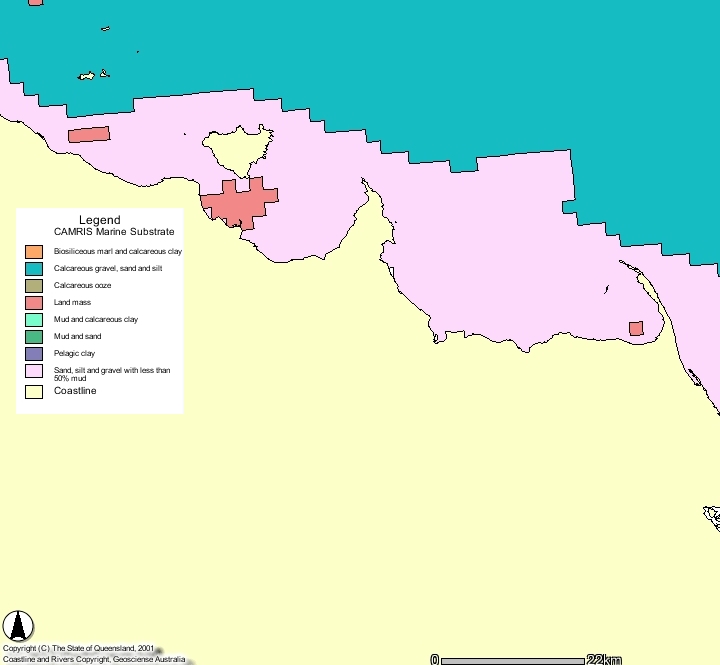
| Attribute Accuracy | Attributes are assumed to be correct. The item called SUBSTRATE describes 9 classes: ----------------------------------------- Biosiliceous marl and calcareous clay Calcareous gravel, sand and silt Calcareous ooze Land mass Mud and calcareous clay Mud and sand Pelagic clay Sand, silt and gravel with less than 50% mud Volcanic sand and grit | |
| Logical Consistency | Coverages are topologically consistent. No particular tests conducted by ERIN | |
| Completeness | Complete | |
| Contact Information | ||
| Contact Organisation | Environment Australia - Environmental Resources Information Network | |
| Contact Position | Project Officer - Heritage Information Team - ERIN | |
| Mail Address | GPO Box 787 | |
| Locality | CANBERRA | |
| State | ACT | |
| Country | Australia | |
| Postcode | 2601 | |
| Telephone | (02) 6274 1046 | |
| Facsimile | (02) 6274 1333 | |
| Electronic Mail | geoff@erin.gov.au | |
| Metadata Date | ||
| Creation Date | 14/03/2002 | |